
Wild British Isles, North Atlantic & Greenland
- 7 Jun ‘27
- 40 nights
- Departing from Greenwich (London)
- Seabourn Venture
-
Balcony price from$50,319*/pp
-
Suite price from$68,679*/pp
YOUR ITINERARY
Greenwich (London), United Kingdom - Dover (London), England - Poole - St. Peter Port, Guernsey - Plymouth, England - Lundy Island, United Kingdom - Criccieth - Bardsey Island - Holyhead, Wales, United Kingdom - Dublin - Calf of Man, Isle of Man - Isle of Man - Brodick, Isle of Arran - Rathlin Island - Belfast, Northern Ireland - Kirkwall - Fair Isle - Mousa, Shetland Islands - Lerwick - Lerwick - Isle of Noss - Vagur - Torshavn, Faroe Island - Klaksvik - Djupivogur, Iceland - Papey Island, Iceland - Grimsey Island - Siglufjorour, Iceland - Dynjandi, Iceland - Patreksfjorour, Iceland - Reykjavik, Iceland - Heimaey, Westman Islands, Iceland - Heimaey, Westman Islands, Iceland - Qaqortoq, Greenland - Hvalsey - Brattahillo - The SBN Southern Greenland - Nanortalik, Greenland - Tasermuit,Greenland - The SBN Southern Greenland - Aapilattoq - Prince Christian Sund - Skjoldungen Fjord, Greenland - Tasiilaq, Greenland - The SBN Southern Greenland - Patreksfjorour, Iceland - Flatey Island, Iceland - Grundarfjordur, Iceland - Reykjavik, Iceland
London is one of the great entertainment, financial and...
London is one of the great entertainment, financial and fashion centers of the world. It dates back to ancient times when the Romans made it a hub of their road system and built the first London Bridge. There are actually two separate cities – the City of London and the City of Westminster – and they function side by side. The City of London is mostly a place of business and finance, while Westminster (the West End) is the locale of the Houses of Parliament and Buckingham Palace, as well as theaters, clubs, parks and myriad shops. *Please note that embarkation and/or disembarkation in London, United Kingdom requires the use of a tender.
Crossing the English Channel from continental Europe to ...
Crossing the English Channel from continental Europe to Great Britain, the first view of England is the milky-white strip of land called the White Cliffs of Dover. As you get closer, the coastline unfolds before you in all its striking beauty. White chalk cliffs with streaks of black flint rise straight from the sea to a height of 350’ (110 m).
Numerous archaeological finds reveal people were present in the area during the Stone Age. Yet the first record of Dover is from Romans, who valued its close proximity to the mainland. A mere 21 miles (33 km) separate Dover from the closest point in France. A Roman-built lighthouse in the area is the tallest Roman structure still standing in Britain. The remains of a Roman villa with the only preserved Roman wall mural outside of Italy are another unique survivor from ancient times which make Dover one of a kind.
Guernsey, the second largest of the Channel Island...
Guernsey, the second largest of the Channel Islands, offers the visitor a mild climate, breathtaking scenery and a peaceful, unspoiled ambiance, all of which combine to make it a popular destination for British and French vacationers. Besides tourism, the island is notable for its highly successful agricultural industry, producing flowers, strawberries and millions of pounds of the coveted “Guernsey Tom,” a juicy succulent tomato.
Plymouth, the largest city in Devon, has a long maritime ...
Plymouth, the largest city in Devon, has a long maritime history. Construction on the Royal Naval Dockyard was begun by William III in the late 17th century, and the site continues to serve as a naval base today. Excellent views of Plymouth Sound, with its many bays and inlets, may be enjoyed from the grassy esplanade known as the Hoe. Although heavy bombing destroyed much of Plymouth during World War II, a fascinating part of the past may still be seen in the Barbican, the oldest surviving section of the city. The Mayflower Steps mark the spot from which the Pilgrims sailed for the New World in 1620. You may wish to take a look inside the massive Royal Citadel, built by Charles II in 1666. The city houses Europe’s premier oceanography institute with an unrivalled aquarium. An excursion into the lovely Devonshire countryside should prove a most pleasant diversion.
A delightful escape from the hubbub of the modern worl...
A delightful escape from the hubbub of the modern world, three-and-a-half-mile-long Lundy Island is located where the Atlantic Ocean meets the Bristol Channel. Roads are undisturbed by cars. Theres a small village, a Victorian church, even a 13th-century castle. The surrounding waters are home to Great Britains first marine nature reserve. On this granite outcropping, there are farms and open moorlands. Seals blanket the eastern shore. Owned by Britains National Trust and maintained by the Landmark Trust, the island evokes a more tranquil time.
Today the city of Holyhead is connected to the larg...
Today the city of Holyhead is connected to the large Welsh island of Anglesey by a causeway known locally as The Cobb, but until the mid-19th century, it was on its own separate Holy Island connected by a bridge. Its protected harbor and location adjacent to the Irish Sea made it an important port from Roman times. Its beautiful St. Cybi’s Church is in fact situated in the remains of a Roman three-walled fort, the Caer Gybi, facing the harbor. The harbor’s three-kilometer breakwater is the longest in the United Kingdom, and made the port a crucial safe haven in inclement weather for ships plying the busy routes to industrial Liverpool and Lancashire. Until the completion of the London to Liverpool railway, Holyhead held the Royal Mail contract for Dublin. Your ship docks today at a jetty that originally served a lucrative aluminum smelting operation, until the closing of a nuclear generating facility cut of the supply of inexpensive power. A waterfront Maritime Museum provides insights into Holyhead’s long history as a seaport. Visitors are welcomed at the picturesque South Stack Lighthouse, and at the adjacent RSPB nature reserve, which offers views of the sea cliffs and their abundant nesting populations of puffins, fulmars, razorbills, guillemots, gannets and other seabirds, as well as seals, dolphins and other wildlife. The Anglesey countryside also holds prehistoric dolmens including the Trefignath Burial Chamber, and a nostalgic old Welsh farmstead called Cyfellion Swtan that charmingly preserves the traditional lifestyle or rural Wales.
Historic Dublin, the capital of Ireland, is rich in tradit...
Historic Dublin, the capital of Ireland, is rich in tradition and heritage. Founded in 841 as a Viking settlement, Dublin remained under Viking rule until the Norman invasion of Ireland in the 12th century.
Divided by the Liffey and Tolka rivers, Dublin is a truly quaint and picturesque city. Bridges, waterways, narrow alleyways, and beautiful Georgian architecture await discovery. Dublin’s 751 pubs support a traditional folk music scene second to none. Wandering along its streets, you cannot avoid noticing the city’s different faces — its cobblestone streets next to modern and mid-century buildings, massive stone churches heavy with the weight of ages, and colorful storefronts with ornate woodcarvings.
The history of Dublin and Ireland itself can be seen through the changes in Dublin Castle. This impressive architectural landmark is one of Ireland’s most iconic symbols. Of traditional Norman design, it was erected in the 13th century to serve as the headquarters for Norman power.
Brodick is the main village on the Isle of Arran, in the Fir...
Brodick is the main village on the Isle of Arran, in the Firth of Clyde, Scotland. It is halfway along the east coast of the island, in Brodick Bay below Goat Fell, the tallest mountain on Arran. The name is derived from the Norse “breda-vick” meaning “Broad Bay”.
Rathlin Island is an island and civil parish off the coa...
Rathlin Island is an island and civil parish off the coast of County Antrim in Northern Ireland. It is Northern Ireland’s northernmost point.
Belfast, Northern Ireland’s largest urban area i...
Belfast, Northern Ireland’s largest urban area is situated on Ireland’s eastern coast. To the northwest, the city is flanked by hills, including Cavehill, thought to be Jonathan Swift’s inspiration for his novel, “Gulliver’s Travels.” Belfast’s location is ideal for the shipbuilding industry that once made it famous. The Titanic was built here in 1912, at the largest shipyard in the world. Until the Good Friday Agreement of 1998 was reached, the worst of Ireland’s “troubles” was experienced in Belfast, which suffered almost half the conflict’s resulting deaths. Since that time, however, Belfast’s city center has emerged into an attractive pedestrian-oriented environment with street musicians and the like, and a revitalized river front.
Kirkwall is the largest town of Orkney, an archipelago to the ...
Kirkwall is the largest town of Orkney, an archipelago to the north of mainland Scotland. The name Kirkwall comes from the Norse name Kirkjuvágr, which later changed to Kirkvoe, Kirkwaa and Kirkwall.
Fair Isle is an island in Shetland, in northern Scotland. ...
Fair Isle is an island in Shetland, in northern Scotland. It lies about halfway between mainland Shetland and Orkney. It is known for its bird observatory and a traditional style of knitting. The island has been owned by the National Trust for Scotland since 1954.
Mousa is a small island in Shetland, Scotland, uninhabited ...
Mousa is a small island in Shetland, Scotland, uninhabited since the nineteenth century. The island is known for the Broch of Mousa, an Iron Age round tower, and is designated as a Special Protection Area for storm-petrel breeding colonies.
Lerwick, Britain’s most northerly town, and is a sma...
Lerwick, Britain’s most northerly town, and is a small, bustling, cosmopolitan seaport with a population of over 7,000 people and fine architecture. Shetland Museum, located on Hay’s Dock, is an award- winning attraction. Discover the island’s many secrets through its exhibits, and take a look in the boat shed, where you can see demonstrations of traditional boat building. Also of interest is the stone-walled town hall, built in 1884, displaying an impressive array of beautifully intricate stained glass. Towering St. Magnus Cathedral, constructed in 1863, is likewise well worth a visit.
People have lived and prospered here since Neolithic times. The site of Clickimin Broch, a hollow-stone-walled structure, was a Late Bronze Age farmstead of the 7th century BCE. Historic Fort Charlotte, built in 1653, is a five-sided fortress, with cannon batteries pointing out to sea. The Shetland Textile Museum, with its fine weaving, and the quaint Crofters Museum will detail life in a much gentler time. The name Lerwick is derived from Norse and means ‘bay of clay.’
Lerwick, Britain’s most northerly town, and is a small, b...
Lerwick, Britain’s most northerly town, and is a small, bustling, cosmopolitan seaport with a population of over 7,000 people and fine architecture. Shetland Museum, located on Hay’s Dock, is an award- winning attraction. Discover the island’s many secrets through its exhibits, and take a look in the boat shed, where you can see demonstrations of traditional boat building. Also of interest is the stone-walled town hall, built in 1884, displaying an impressive array of beautifully intricate stained glass. Towering St. Magnus Cathedral, constructed in 1863, is likewise well worth a visit.
People have lived and prospered here since Neolithic times. The site of Clickimin Broch, a hollow-stone-walled structure, was a Late Bronze Age farmstead of the 7th century BCE. Historic Fort Charlotte, built in 1653, is a five-sided fortress, with cannon batteries pointing out to sea. The Shetland Textile Museum, with its fine weaving, and the quaint Crofters Museum will detail life in a much gentler time. The name Lerwick is derived from Norse and means ‘bay of clay.’
A distant outpost of Denmark, the Faroe Islands suddenly appear ...
A distant outpost of Denmark, the Faroe Islands suddenly appear out of the misty North Atlantic, nearly 200 miles from the nearest landfall. Of the twenty-two islands in the group, seventeen are inhabited, with a population of 17,000 residing in the capital city of Torshavn. Irish monks discovered the islands in the 8th century and became the first settlers, only to be driven out by Viking explorers a century later. The traditions and legends of their Viking forefathers are kept alive in a language so close to old Norse that Faroe Islanders can still read the ancient texts inscribed centuries ago. The name Faroe comes from faereyjar, the Old Norse word meaning “Sheep Islands.” With thousands of sheep dotting the hillsides, the name remains apt today. While sheep are important to the economy, the real wealth of the islands comes from the fishing industry. A fleet of over 300 trawlers and line-fishing boats bring in an average annual haul of 245,000 tons of cod and herring. Ultra-modern processing and freezing plants do the job of getting the product to market in the most efficient manner.
Djúpivogur is a very small, quaint town of some 456 people,...
Djúpivogur is a very small, quaint town of some 456 people, located in East Iceland in Berufjörður fjord. Towering, pyramid-shaped Mount Búlandstindur dominates the landscape, rising to 3,510’ (1,069 m). It is a place of unspoiled nature, with quiet lagoons and a tranquil harbor populated by colorful fishing boats. The area is well-known for the diversity of birdlife, especially in nearby Búlandsnes Bird Sanctuary where most of Iceland’s bird species can be observed.
Time seems to flow more slowly here, because the residents have chosen a much different lifestyle, enriched with opportunities to observe their natural surroundings. Djúpivogur is a creative community, displaying its local arts and crafts in workshops and galleries. The Eggs of Merry Bay, ‘Eggin í Gleðivík,’ is a large outdoor art installation by renowned Icelandic artist Sigurður Guðmundsson. It consists of 34 large sculpted stone eggs representing the 34 bird species found in the vicinity. Located only a kilometre from the town center, it makes an easy and pleasant stroll along the shore.
Siglufjörður is the northernmost town on the Ice...
Siglufjörður is the northernmost town on the Icelandic mainland, a small fishing village of some 1,200 people. Founded in 1918, it was in the past the capital of the North Atlantic herring fishing industry. The Síldarminjasafnið Herring Era Museum, one of Iceland’s largest seafaring and industrial museums, houses three different areas where one can learn about both the traditional and the modern herring industry. A collection of many historic fishing vessels and artifacts is proudly displayed by the people of Siglufjörður, detailing how herring was salted, processed and collected. The small harbor with its colorful fishing boats and the red-roofed steeple of the Lutheran church dominate the village-scape.
The natural beauty of the area includes high mountains that rim the fjord, freshwater lakes, the Hólsá river, black sand beaches, and a wealth of birdlife all around. This northernmost region of Iceland is renowned for some of the largest and most dramatic waterfalls in the country.
Warmed by the Gulf Stream as well as by highly active therm...
Warmed by the Gulf Stream as well as by highly active thermal hot springs and volcanoes, Iceland is somewhat misnamed. While it is a stark and barren country with three huge areas of glaciers, one theory is that early Norsemen sought to mislead other potential settlers by giving a pleasant name to fierce, inhospitable Greenland, and a forbidding name to the imminently habitable Iceland. Irish monks and hermits established themselves here in the 8th century, but left a century later when the pagan Norsemen arrived. Europe’s first Parliament of General Assembly, the Althing, was established in the year 930 and still functions as the legislative body, although it was suspended by the Danes at the end of the 18th century and not reconvened until 1843. Reykjavik was the site picked by the island’s first permanent resident, Ingolfur Arnarson in 874, and is home to more than half of the island’s total population. The world’s northernmost capital, Reykjavik is proud of its virtual lack of air pollution. Both electrical power and home heating are derived from the geothermal activity on the island. The city’s large swimming pools are always warm, and in the countryside exotic fruits such as grapes and bananas are cultivated in greenhouses made cozy with the help of underground hot springs.
The largest town in South Greenland with over 3,500 citizens...
The largest town in South Greenland with over 3,500 citizens, Qaqortoq was founded in 1775 and still reveals some examples of colonial-period architecture. There is not infrastructure to support shore excursions here, but guests can explore the town and its museum, or possibly arrange a visit to a nearby hot springs. Like other towns in Greenland, there are also possibilities to buy examples of traditional Inuit arts and crafts, including items crafted of bone, soapstone and wild-harvested furs.
Twelve miles by Zodiac up the Hvalseyjarfjord from Qaqorto...
Twelve miles by Zodiac up the Hvalseyjarfjord from Qaqortoq, the largest community in South Greenland, lies the most prominent Norse archaeological site in Greenland. The so-called Eastern Settlement lasted from the 10th until the mid-15th century. Your expedition team archaeologist can interpret for you the ruins of the great halls and church at Hvalsey that hint of a prospering medieval farmstead. The site evokes an era when the Norse were trading with the indigenous Thule people of the area for furs and ivory, which were a prized commodities in Europe. A wedding held in the church in 1408 comprises the last written record of the Norse adventure in Greenland. Within a few years, Hvalsey and the rest of other Norse communities of Greenland withered as immigrants returned to the more established communities in Iceland and Norway. The site’s meadows of wildflowers sloping up from the fjord give a sense of the peaceful community that existed here in that long-ago summer.
The immense scale of the peaks around this village ...
The immense scale of the peaks around this village dwarfs anything built there. Still, the tall white steeple of the church juts up with a spirit of endurance and perseverance that matches the character of those who make this arctic outpost their home. It also echoes the shape of icebergs floating in the surrounding seas, shed from the immense icefields that cover much of the island.
Tiny Aappilattoq is located in the Prince Christian Sound ...
Tiny Aappilattoq is located in the Prince Christian Sound at Greenland’s southern tip, in the municipality of Kullaleq. Its name means ‘red’ in Greenlandic. The sound is enfolded by steep, unglaciated mountains, rising sheer from the water to sharp, shattered peaks. The town’s setting is particularly picturesque, its brightly painted houses scattered across a small peninsula of humped granite domes, under a backdrop of a looming pyramid of stone. The little red town church nestles next to a white-picketed graveyard. The sound itself is dotted with icebergs slowly melting into expressionist sculptures. It is a place where the infrequent visitors routinely fill their camera cards with unforgettable images of Greenland’s spectacular visual splendor.
Imagine a narrow fjord bordered by rugged peaks, vertical r...
Imagine a narrow fjord bordered by rugged peaks, vertical rock walls and serpentine rivers of ice plunging into the sea. This is Skjoldungen Fjord, named by Wilhelm August Graah after the honorific title Skjoldungen which, according to Norse mythology, was given to successors of legendary King Skjold to the Danish throne.
Numerous tidewater glaciers calve during the summer, releasing large chunks of ice that plunge into the fjord. Above, huge crevasses and free-standing pillars of ice, known as seracs, are silhouetted against a blue Greenlandic sky. Barren of large trees, Skjoldungen Fjord is carpeted in colorful dwarf birch and willow forests that may grow several feet high, as well as a variety of low-growing Arctic wildflowers.
This fjord was likely inhabited by Paleo-Eskimo (Inuit) nomadic people as early as 4,000 years ago. Archaeological remains of later historical periods, such as Thule culture graves, have also been found, indicating that Inuit people have lived in the area continuously. Scattered within this stunning scenery are remains of more recent abandoned Inuit dwellings along the fjord’s western shores.
Tasiilaq, formerly Ammassalik and Angmagssalik, is a town in t...
Tasiilaq, formerly Ammassalik and Angmagssalik, is a town in the Sermersooq municipality in southeastern Greenland. With 1,985 inhabitants as of 2020, it is the most populous community on the eastern coast, and the seventh-largest town in Greenland.
The charming small fishing village of Grundarfjörður i...
The charming small fishing village of Grundarfjörður is located in the middle of the Snæfellsnes Peninsula and thus provides easy access to Stykkishólmur, Snæfellsbær and the Snæfellsnes National Park. Its best-known landmark is undoubtedly the peak of Mt. Kirkjufell. Translated as ‘church mountain,’ Kirkjufell is the most easily recognizable peak, and one of the most photographed mountains in Iceland. During summer months a Viking Village is built in the center of town where Viking re-enactments occur quite regularly. During the Á góðri stund town festival in July, the town’s 900 residents decorate their houses in red, blue, yellow, and green, transforming the town into a spinning kaleidoscope of color.
The town first began trade in 1786, and around 1800, French merchants came to Iceland and settled in Grundarfjörður, where they constructed a church and a hospital. The town has prospered through the fishing industry for a long time. The surrounding sea is rich with birdlife & marine life throughout the year.
Warmed by the Gulf Stream as well as by highly active ther...
Warmed by the Gulf Stream as well as by highly active thermal hot springs and volcanoes, Iceland is somewhat misnamed. While it is a stark and barren country with three huge areas of glaciers, one theory is that early Norsemen sought to mislead other potential settlers by giving a pleasant name to fierce, inhospitable Greenland, and a forbidding name to the imminently habitable Iceland. Irish monks and hermits established themselves here in the 8th century, but left a century later when the pagan Norsemen arrived. Europe’s first Parliament of General Assembly, the Althing, was established in the year 930 and still functions as the legislative body, although it was suspended by the Danes at the end of the 18th century and not reconvened until 1843. Reykjavik was the site picked by the island’s first permanent resident, Ingolfur Arnarson in 874, and is home to more than half of the island’s total population. The world’s northernmost capital, Reykjavik is proud of its virtual lack of air pollution. Both electrical power and home heating are derived from the geothermal activity on the island. The city’s large swimming pools are always warm, and in the countryside exotic fruits such as grapes and bananas are cultivated in greenhouses made cozy with the help of underground hot springs.
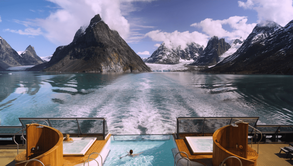
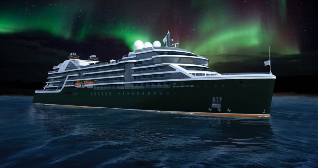
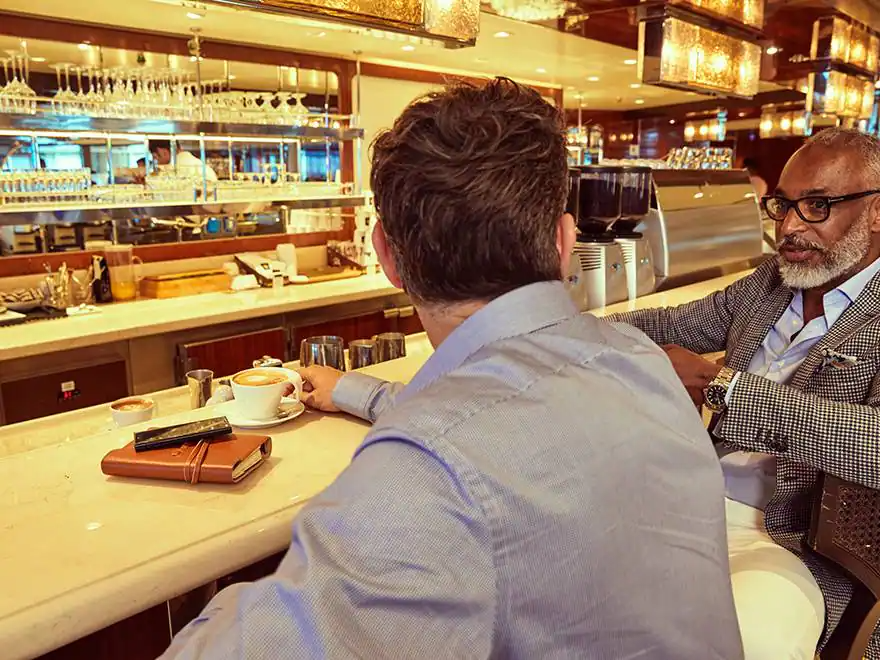
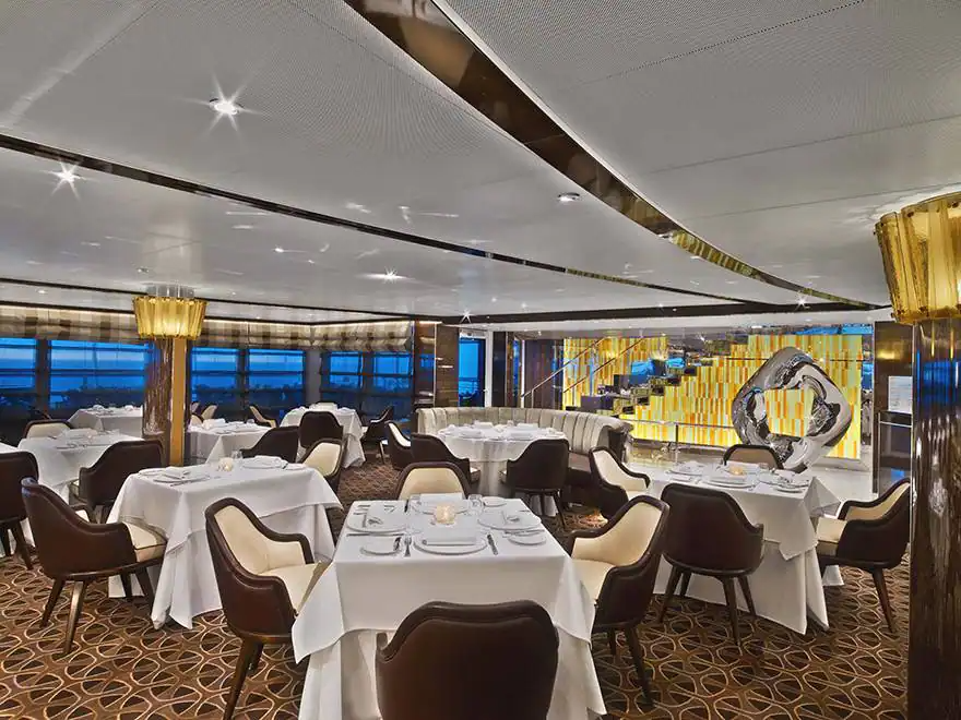
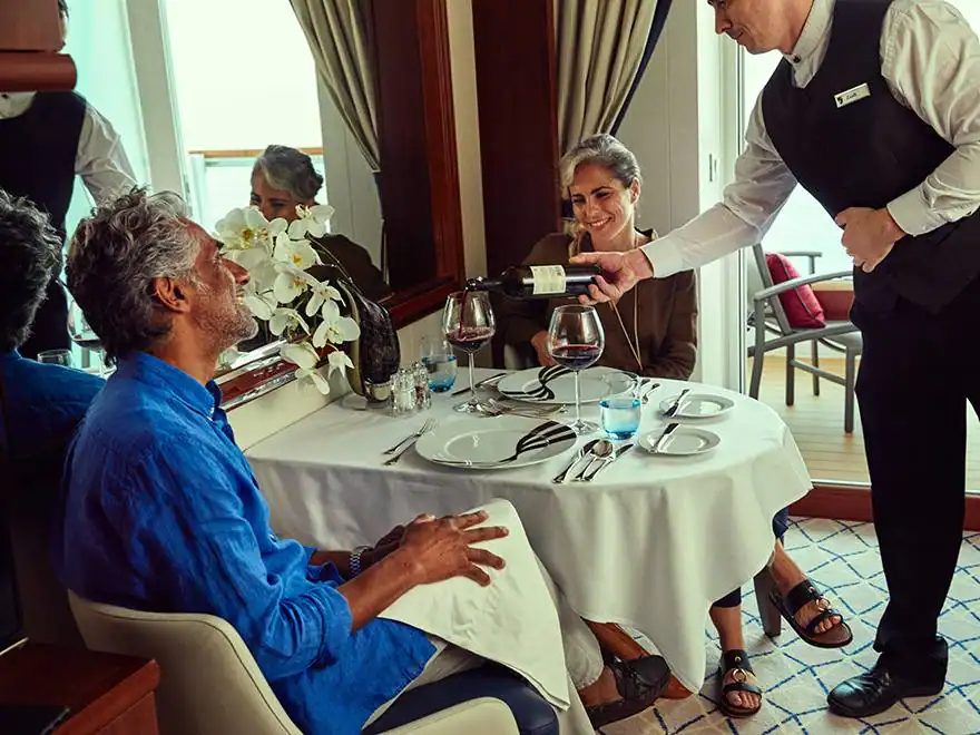
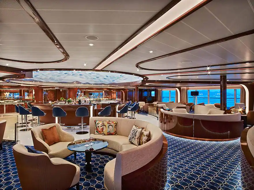
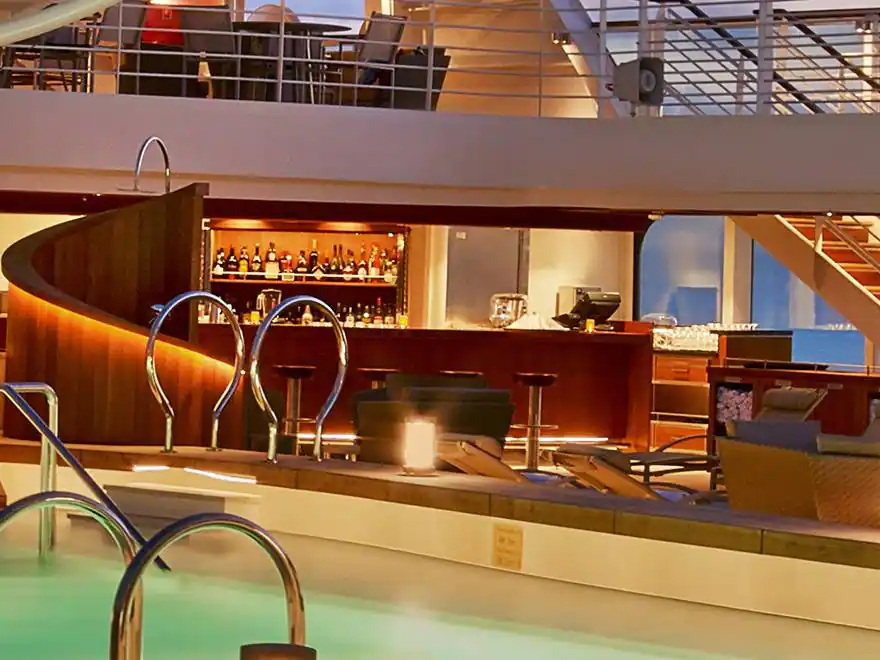
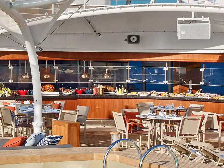
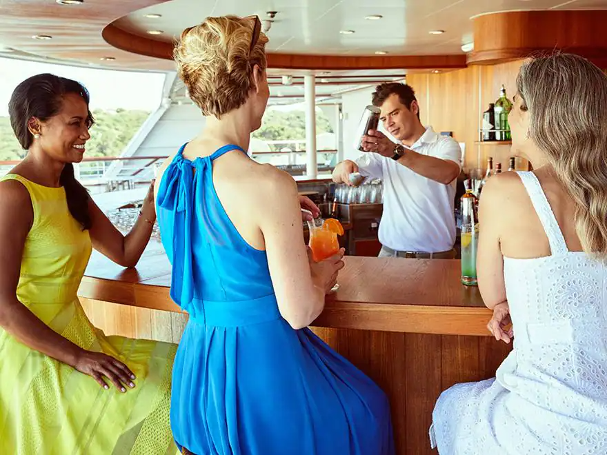
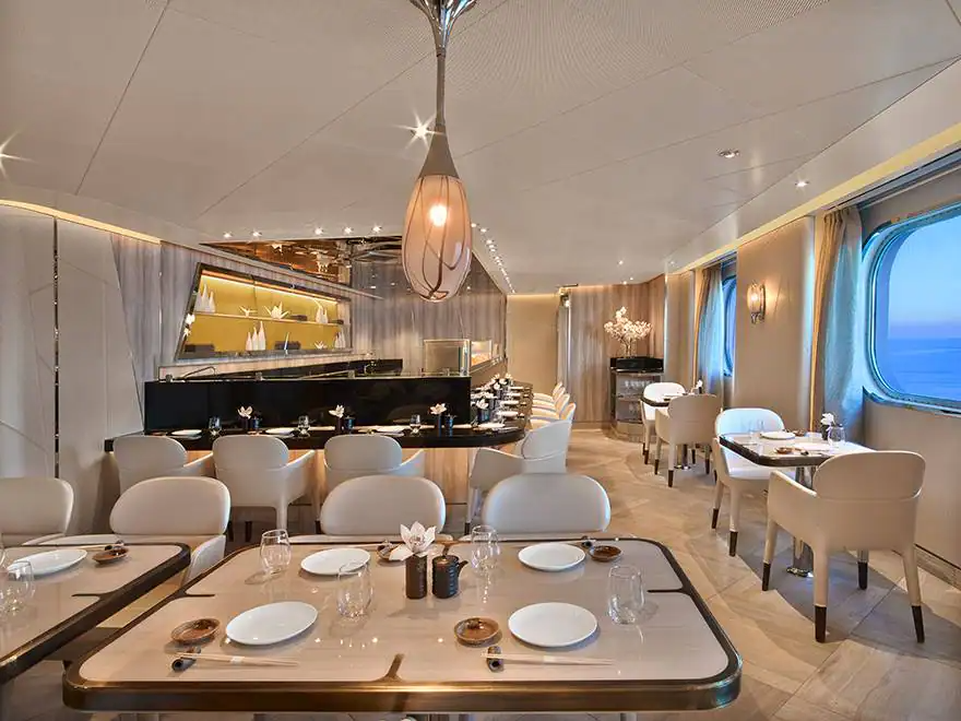
YOUR SHIP - The Seabourn Venture
Seabourn’s ultra-luxury purpose-built expedition ship Seabourn Venture, paying tribute to the remote destinations visited by the brand’s highly successful expedition and Ventures by Seabourn excursion programs and the fascinating places yet to be explored in the future.
Seabourn Venture is scheduled to launch in June 2021, with a second yet-to-be-named sister ship slated to launch in May 2022. Both ships will be designed and built for diverse environments to PC6 Polar Class standards and will include a plethora of modern hardware and technology that will extend the ships global deployment and capabilities. The new ships, which are being built by T. Mariotti, will be a brand new innovative design, created specifically for the ultra-luxury expedition traveler, and will include many features that have made Seabourn ships so successful.
A new and exciting offering will be two custom-built submarines carried onboard, providing an unforgettable view of the world beneath the ocean’s surface. The ships will also be designed to carry a complement of double sea kayaks, mountain bikes and ebikes as well as 24 Zodiacs that can accommodate all onboard guests at once, which will allow for a truly immersive experience. Each ship will feature 132 all veranda, all ocean-front suites.
Description
Seabourn’s ultra-luxury purpose-built expedition ship Seabourn Venture, paying tribute to the remote destinations visited by the brand’s highly successful expedition and Ventures by Seabourn excursion programs and the fascinating places yet to be explored in the future.
Seabourn Venture is scheduled to launch in June 2021, with a second yet-to-be-named sister ship slated to launch in May 2022. Both ships will be designed and built for diverse environments to PC6 Polar Class standards and will include a plethora of modern hardware and technology that will extend the ships global deployment and capabilities. The new ships, which are being built by T. Mariotti, will be a brand new innovative design, created specifically for the ultra-luxury expedition traveler, and will include many features that have made Seabourn ships so successful.
A new and exciting offering will be two custom-built submarines carried onboard, providing an unforgettable view of the world beneath the ocean’s surface. The ships will also be designed to carry a complement of double sea kayaks, mountain bikes and ebikes as well as 24 Zodiacs that can accommodate all onboard guests at once, which will allow for a truly immersive experience. Each ship will feature 132 all veranda, all ocean-front suites.
STATEROOMS
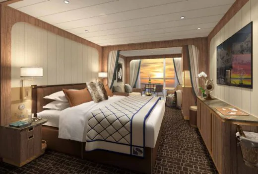
suite
